Knowledge initiative between the Lal Bahadur Shastri National Academy of Administration (LBSNAA) Government of India and the Geographic Insights Lab at the Harvard Center for Population and Development Studies (HCPDS).
Progress on key issues related to health, nutrition and population requires policies and actions that are geographically precise and effective. The Geographic Insights Lab focuses on units that bring geographic precision and political engagement that could guide efficient resource allocation decisions, targeted policy actions and performance monitoring and evaluations. The lab is developing rigorous data science solutions, creating value-added data and undertaking scientific inquiry to improve precision in policy governance and action.
Currently, public policy discussions and decisions around population health and development in India are limited to data that is collected and reported at broader levels of districts or states. Yet, recent research has shown there to be significant variation in key indicators of population health and development within these macro levels, underscoring the importance of disaggregated zones of villages and Gram Panchayat (GP). Parliamentary Constituency (PC) and Assembly Constituency (AC) are also key public policy units, but political representatives at these units have been left in the dark about the particular needs of their constituents due to data limitations. Bringing both people as well as their elected representatives into development governance is important in itself as well as to complement the effectiveness of district administration.
The Harvard Center for Population and Development Studies faculty member S (Subu) V Subramanian, PhD, and visiting scientist Rockli Kim, ScD from Korea University, have been awarded a grant to improve precision public policy, public financing, and governance in India related to indicators of population health and development. By leveraging novel geospatial and statistical methodologies, a major aim of the project is to collate and analyze population health and development data geocoded to multiple micro and macro public policy units (GPs, ACs, and PCs) and make robust predictions at each level.
India has the second-highest number of confirmed cases and ranks third for the greatest number of COVID-19 deaths since September 2020. The Geographic Insights Lab presents the first COVID-19 metrics and data visualization for 543 Parliamentary Constituencies in India (see below) that allows elected officials and their constituents to monitor and develop testing and vaccine deployment strategies to efficiently enable the reopening of the country.
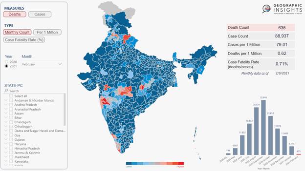
© Authors: Akhil Kumar, Weixing Zhang, S V Subramanian. Geovisualizing COVID-19 Metrics across Parliamentary Constituencies in India. December 2020, Cambridge MA, Harvard Center for Population and Development Studies.
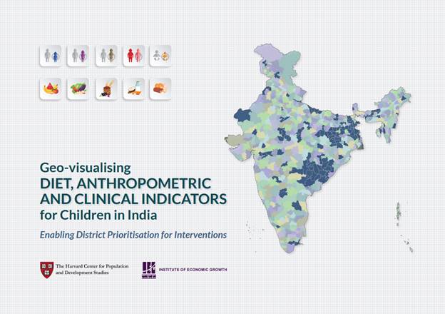
Geo-visualisation is provided for 31 indicators that include diet, anthropometry, clinical and service utilization measures of child nutrition for the districts of India to help stakeholders prioritise indicators and districts for interventions. The need for such prioritisation has become particularly urgent in light of the recently released NFHS-5 statistics on undernutrition.The novel features of the atlas include:
Developing a new metric to rank districts that considers both the prevalence (%) and the headcount of children experiencing the burden (i.e., a Prevalence-Headcount Metric);
Presenting an indicator-specific 100 priority districts for nutritional interventions; and
Explicitly focusing on diet-related measures of undernutrition
The atlas is also accompanied by an interactive dashboard for users to explore the underlying data as follows:
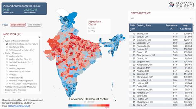
© Authors: Akhil Kumar, Weixing Zhang, S V Subramanian. Dashboard on Geo-visualising Diet, Anthropometric and Clinical Indicators for Children in India. December 2020, Cambridge MA, Harvard Center for Population and Development Studies.